
CABO SAN LUCAS, Mexico (AP) — Two newly formed tropical depressions at opposite ends of the Caribbean were expected to become tropical storms Friday, with forecasters projecting potential tracks for both that could take them toward the United States, possibly as hurricanes.
The U.S. National Hurricane Center said Tropical Depression 13 has become Tropical Storm Laura. Friday morning, the system was centered about 230 miles east of the northern Leeward Islands with maximum sustained winds of 45 mph and it was headed briskly to the west-northwest at 21 mph.
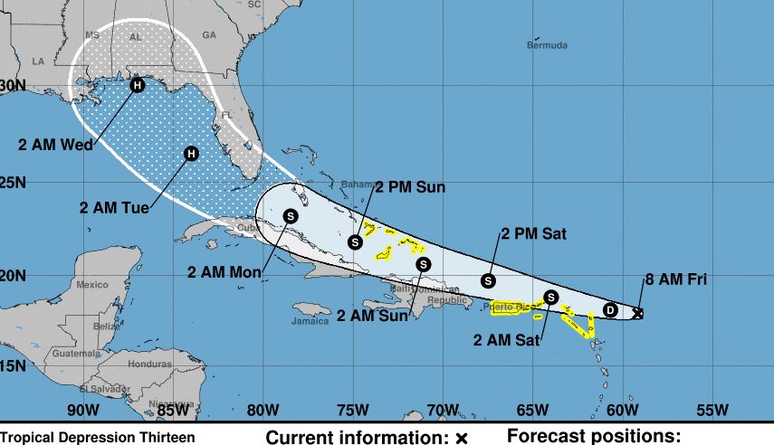
Forecasters earlier described it as as a disorganized storm with a very uncertain future. The Hurricane Center said it might degenerate, or it might blow up into a major hurricane that could hit Florida by Monday or Tuesday and then the Gulf Coast.
The current forecast track, also highly uncertain, would carry it just north of Puerto Rico, the Dominican Republic and Cuba, across the Bahamas en route to the U.S.
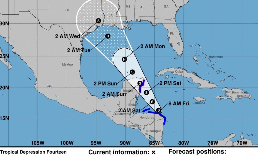
Meanwhile, Tropical Depression 14 was nearing the coast of Honduras Friday morning, and the U.S. National Hurricane Center said it was expected to veer northwest and cut across the tip of Mexico's Yucatan Peninsula Sunday, possibly at or near hurricane force.
From there, the long-term forecast track would carry it to the U.S. Gulf Coast, perhaps Texas or Louisiana, by Tuesday or Wednesday — again, possibly, as a hurricane
On Friday morning, it was centered about 160 miles east of the Honduran resort island of Roatan with 35 mph winds. It was headed west-northwest at 12 mph.
Tropical Storm Genevieve in the Pacific, meanwhile, continued to weaken as it remained offshore from Mexico's southern Baja California peninsula while sweeping the coast with strong winds and rain that carried the threat of dangerous flooding.
Genevieve, which had been a powerful Category 4 hurricane with winds of 130 mph on Tuesday, had weakened to a tropical storm Thursday as it moved northwestward in the Pacific off Mexico's Los Cabos tourist resorts. The hurricane center said the storm was expected to continue weakening through the night, likely becoming a tropical depression by Friday evening.
The hurricane center said Genevieve’s maximum sustained winds had dropped to 50 mph Friday morning, and it was centered about 130 miles west-southwest of Cabo San Lazaro. It was moving to the west-northwest at 10 mph.
The storm knocked out power and phone service to a large part of the Los Cabos area, flooded streets in poor neighborhoods and toppled palms in the tourist zone. High surf claimed two lives Tuesday as the storm approached the area.
Baja California Sur state officials said 15,000 foreign tourists were in the state, most in the Los Cabos region, which earlier had almost been emptied of visitors by pandemic restrictions.