***Update:
From the National Hurricane Center:
KEY MESSAGES:
1. Potentially life-threatening flash and urban flooding is likely through Thursday across Louisiana and southern Mississippi, and is possible near the Upper Texas coast. Flash flooding is also possible across Alabama, Georgia, and the Florida Panhandle through the end of the week. Prolonged rainfall may extend the flood threat into the weekend.
2. Tropical-storm force winds are expected along the Louisiana coast on Wednesday from Sabine Pass to Morgan City where a Tropical Storm Warning is now in effect.
3. Minor to moderate coastal flooding is expected along portions of the Upper Texas and Louisiana coastlines.
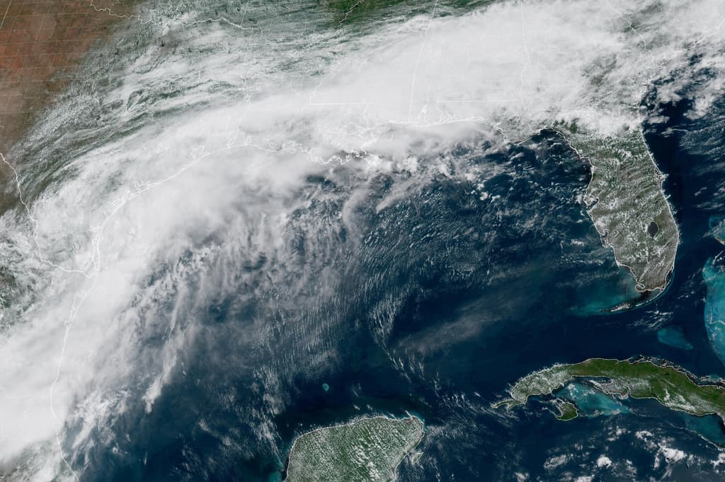
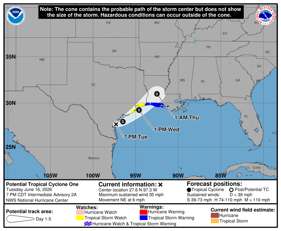
The low pressure area continues to produce disorganized deep convection mostly over water, almost exclusively in the eastern semicircle. However, the low-level center has become better defined during the day according to satellite and surface data, along with falling pressures. While the system is fairly close to transitioning into a tropical depression, it is still a bit shy of a well-defined center and consistent convection. Thus the system remains a potential tropical cyclone, and the initial intensity is 25 kt based on surface and radar data.
The low continues to slowly move northeastward. It is expected to move offshore of south Texas tonight and accelerate northeastward along the coast on Wednesday due to the system encountering faster flow associated with a mid-latitude trough over the eastern United States. Model guidance is about the same as before, moving very near the Texas coast on Wednesday before going back onshore late Wednesday or Wednesday night. No significant changes were made to the track forecast. The circulation is expected to quickly dissipate over central Louisiana on Thursday.
The center should move far enough offshore on Wednesday for some intensification to occur due to a combination of warm Gulf waters and upper-level jet dynamics. Most of the guidance show the system becoming a tropical storm tomorrow, and the official forecast is basically an update of the previous one. Regardless of whether the system becomes a tropical cyclone, heavy rainfall and life-threatening flash flooding will be the primary hazards with this system.
(earlier)
MIAMI (AP) — A cluster of storms along the Gulf Coast of Texas could become the first named tropical storm of the 2026 Atlantic hurricane season, the National Hurricane Center said.
The storms threatened to bring heavy downpours that could lead to dangerous floods across southern states including Texas and Louisiana. The system was centered Tuesday morning about 65 miles southwest of Corpus Christi, Texas, according to a hurricane center advisory.
National Hurricane Center director Michael Brennan said meteorologists are expecting the system to strengthen, possibly into a tropical storm. But coastal areas of Texas and Louisiana could experience tropical storm conditions this week, even if the system doesn’t officially get a name, Brennan said.
“The main hazard with these types of systems is largely the flooding from the heavy rainfall,” Brennan said. “And we could see potentially life-threatening flash and urban flooding across the Texas coast eastward into central Mississippi through Thursday. Prolonged rainfall may extend the flood threat into the weekend.”
The storm's maximum sustained winds were around 30 mph (45 kph) Tuesday morning, just shy of the 39 mph (63 kph) needed to be named a tropical storm.
Houston, where a World Cup match between Portugal and the Democratic Republic of the Congo is scheduled for Wednesday, has been under a flood warning since Monday. The stadium is covered, and no plans have been announced to move or reschedule the match.