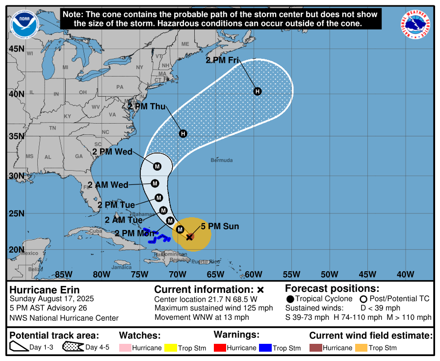
SAN JUAN, Puerto Rico (AP) — Hurricane Erin weakened to a Category 3 hurricane on Sunday, its outer bands lashing the Virgin Islands and Puerto Rico, as forecasters warned the storm was rapidly growing in size and would gain new strength.
While Erin's maximum winds diminished, its overall size grew and forecasters issued tropical storm warnings for the Turks and Caicos Islands and the southeast Bahamas. The hurricane's outer bands were pelting parts of Puerto Rico and the Virgin Islands with heavy rains and tropical-storm winds during the day.
The storm wasn't expected to directly hit the U.S. East Coast, but by doubling or tripling in size its impacts threatened the North Carolina Outer Banks, the thin, low stretch of barrier islands off the mainland, that poke far out into the Atlantic Ocean, Dare County emergency officials said as they declared a state of emergency.
They ordered an evacuation of Hatteras Island starting Monday. Several days of heavy surf and high winds and waves could wash out parts of North Carolina Highway 12 which connects the popular vacation spot to the mainland, the National Weather Service said.
From the National Hurricane Center:
Erin has been growing in size, and that trend is likely to continue over the next few days. The expanding wind field will result in rough ocean conditions over much of the western Atlantic. It should be noted that the 34- and 50-kt wind speed probabilities beyond 36 hours in the text and graphical products are likely underestimating the risk of those winds occurring. This is because the forecast wind field of Erin is considerably larger than average compared to the wind field used to derive the wind speed probability product.
KEY MESSAGES: 1. Bands of heavy rainfall will continue across portions of Puerto Rico and the Virgin Islands through tonight, but are expected to diminish by Monday. Locally considerable flash and urban flooding, along with landslides or mudslides, are possible.
2. Tropical storm conditions are expected in the Turks and Caicos Islands and in the southeast Bahamas tonight and Monday.
3. Erin is expected to produce life-threatening surf and rip currents along the beaches of the Bahamas, much of the east coast of the U.S., Bermuda, and Atlantic Canada during the next several days.
4. Interests along the Outer Banks of North Carolina and Bermuda should monitor the progress of Erin as there is a risk of strong winds associated with the outer rainbands during the middle part of the week.
The center of the storm is forecast to stay at least 200 miles (320 kilometers) from the Outer Banks but will also bring rip tides all along the East Coast, officials said.
Bermuda could have similar conditions as Erin is forecast to turn to the north and then northeast, forecasters said.
Erin, the first Atlantic hurricane of 2025, reached an exceedingly dangerous Category 5 status Saturday with maximum winds of 160 mph (260 kph) before weakening. The storm's maximum sustained winds were 125 mph (205 kph) Sunday afternoon, according to the National Hurricane Center in Miami.
The winds decreased as the storm went through internal changes. Erin is expected to remain powerful for the next several days and is expected to strengthen somewhat over the next 48 hours as it grows, forecasters said Sunday afternoon.
“You’re dealing with a major hurricane. The intensity is fluctuating. It’s a dangerous hurricane in any event,” said Richard Pasch of the National Hurricane Center.
Erin's center was about 275 miles (445 kilometers) northwest of San Juan, Puerto Rico, and 165 miles (270 kilometers) east of Grand Turk Island, moving west-northwest at 13 mph (20 kph). On the forecast track, the core of Erin was expected to pass to the east and northeast of the Turks and Caicos and the southeastern Bahamas overnight and on Monday.
The rain and winds from the outer bands of the storm left about 147,000 customers without power Sunday morning in Puerto Rico, according to Luma Energy, a private company that oversees the transmission and distribution of power on the island. The weather canceled more than 20 flights, officials said.
Swells were also expected to affect portions of the Virgin Islands, Puerto Rico, Hispaniola and the Turks and Caicos Islands during the next couple of days, forecasters said.
The Coast Guard allowed all ports in Puerto Rico and the U.S. Virgin Islands to reopen on Sunday as winds and rains in the area decrease.
A tropical storm warning means tropical storm conditions are expected somewhere within the warning area, and in this case, within 24 hours, the hurricane center said. Heavy rain is still expected across the Virgin Islands and Puerto Rico, with rainfall of 3 to 6 inches (about 7.6 to 15 centimeters), with 8 inches (20 centimeters) in some isolated areas.
Scientists have linked the rapid intensification of hurricanes in the Atlantic to climate change. Global warming is causing the atmosphere to hold more water vapor and is spiking ocean temperatures, and warmer waters give hurricanes fuel to unleash more rain and strengthen more quickly.