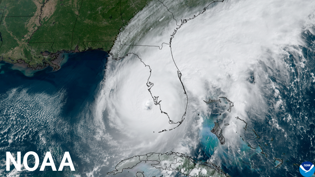
“As we saw with Hurricane Ian, it only takes one hurricane to cause widespread devastation and upend lives. So regardless of the number of storms predicted this season, it is critical that everyone understand their risk..."
NOAA forecasters with the Climate Prediction Center, a division of the National Weather Service, predict near-normal hurricane activity in the Atlantic this year. NOAA’s outlook for the 2023 Atlantic hurricane season, which goes from June 1 to November 30, predicts a 40% chance of a near-normal season, a 30% chance of an above-normal season and a 30% chance of a below-normal season.
NOAA is forecasting a range of 12 to 17 total named storms (winds of 39 mph or higher). Of those, 5 to 9 could become hurricanes (winds of 74 mph or higher), including 1 to 4 major hurricanes (category 3, 4 or 5; with winds of 111 mph or higher). NOAA has a 70% confidence in these ranges.
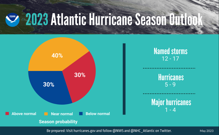
A summary infographic showing hurricane season probability and numbers of named storms predicted from NOAA's 2023 Atlantic Hurricane Season Outlook. (Image credit: NOAA)
“Thanks to the Commerce Department and NOAA’s critical investments this year in scientific and technological advancements in hurricane modeling, NOAA will be able to deliver even more accurate forecasts, helping ensure communities have the information they need to prepare for and respond to the destructive economic and ecological impacts of Atlantic hurricanes,” said Secretary of Commerce Gina M. Raimondo.
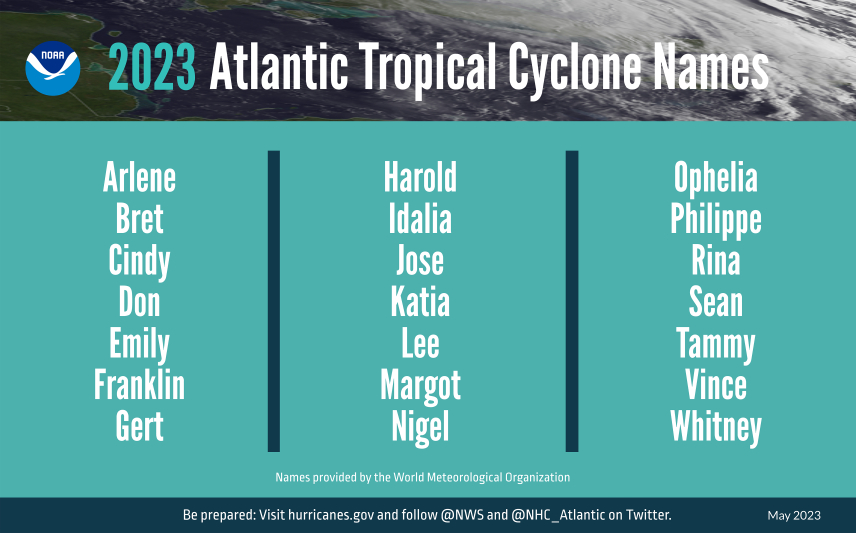
A summary graphic showing an alphabetical list of the 2023 Atlantic tropical cyclone names as selected by the World Meteorological Organization. The official start of the Atlantic hurricane season is June 1 and runs through November 30. (Image credit: NOAA)
The upcoming Atlantic hurricane season is expected to be less active than recent years, due to competing factors — some that suppress storm development and some that fuel it — driving this year's overall forecast for a near-normal season.
After three hurricane seasons with La Nina present, NOAA scientists predict a high potential for El Nino to develop this summer, which can suppress Atlantic hurricane activity. El Nino’s potential influence on storm development could be offset by favorable conditions local to the tropical Atlantic Basin. Those conditions include the potential for an above-normal west African monsoon, which produces African easterly waves and seeds some of the stronger and longer-lived Atlantic storms, and warmer-than-normal sea surface temperatures in the tropical Atlantic Ocean and Caribbean Sea which creates more energy to fuel storm development. These factors are part of the longer term variability in Atlantic atmospheric and oceanic conditions that are conducive to hurricane development — known as the high-activity era for Atlantic hurricanes — which have been producing more active Atlantic hurricane seasons since 1995.
“With a changing climate, the data and expertise NOAA provides to emergency managers and partners to support decision-making before, during and after a hurricane has never been more crucial,” said NOAA Administrator Rick Spinrad, Ph.D. “To that end, this year we are operationalizing a new hurricane forecast model and extending the tropical cyclone outlook graphic from five to seven days, which will provide emergency managers and communities with more time to prepare for storms.”
This summer, NOAA will implement a series of upgrades and improvements. NOAA will expand the capacity of its operational supercomputing system by 20%. This increase in computing capability will enable NOAA to improve and run more complex forecast models, including significant model upgrades this hurricane season:
- In late June, the Hurricane Analysis and Forecast System (HAFS) will become operational. HAFS will run this season in tandem with the currently operational Hurricane Weather Research and Forecast Model System and Hurricanes in a Multi-scale Ocean-coupled Non-hydrostatic model, but eventually will become NOAA’s primary hurricane model. Retrospective analysis of tropical storms and hurricanes from the 2020-2022 seasons show that this model has a 10-15% improvement in track forecasts over existing operational models. This new model was jointly created by NOAA's Atlantic Oceanographic & Meteorological Laboratory Hurricane Modeling and Prediction Program and NOAA’s National Weather Service Environmental Modeling Center.
- The Probabilistic Storm Surge model upgrade on May 2, advances storm surge forecasting for the contiguous U.S. and new forecasts for surge, tide and waves for Puerto Rico and the U.S. Virgin Islands. Forecasters now have the ability to run the model for two storms simultaneously. This model provides forecasters with the likelihood, or probability, of various flooding scenarios including a near worst-case scenario to help communities prepare for all potential outcomes.
Additional upgrades or new tools for hurricane analysis and forecasting include:
- The National Hurricane Center’s Tropical Weather Outlook graphic, which shows tropical cyclone formation potential, has expanded the forecast range from five to seven days.
- Over the last 10 years, flooding from tropical storm rainfall was the single deadliest hazard. To give communities more time to prepare, the Weather Prediction Center is extending the Excessive Rainfall Outlook an additional two days, now providing forecasts up to five days in advance. The outlook shows general areas at risk for flash flooding due to excessive rainfall.
- The National Weather Service will unveil a new generation of forecast flood inundation mapping for portions of Texas and portions of the Mid-Atlantic and Northeast in September 2023. These forecast maps will extend to the rest of the U.S. by 2026. Forecast flood inundation maps will show the extent of flooding at the street level.
NOAA will continue improving new and current observing systems critical in understanding and forecasting hurricanes. Two projects underway this season include:
- New small aircraft drone systems, the deployment of additional Saildrones and underwater gliders, and WindBorne global sounding balloons. These new technologies will advance our knowledge of hurricanes, fill critical data gaps and improve hurricane forecast accuracy.
- The modernization and upgrade of the Tropical Atmosphere Ocean buoy array. The upgrade will provide additional capabilities, updated instruments, more strategic placement of buoys and higher-frequency observations. Data from these buoys are used to forecast El Nino and La Nina, which can influence hurricane activity.
“As we saw with Hurricane Ian, it only takes one hurricane to cause widespread devastation and upend lives. So regardless of the number of storms predicted this season, it is critical that everyone understand their risk and heed the warnings of state and local officials. Whether you live on the coast or further inland, hurricanes can cause serious impacts to everybody in their path,” said FEMA Administrator Deanne Criswell. “Visit ready.gov or listo.gov for readiness resources, and get real time emergency alerts by downloading the FEMA App. Actions taken today can save your life when disaster strikes. The time to prepare is now.”
NOAA’s outlook is for overall seasonal activity and is not a landfall forecast. In addition to the Atlantic seasonal outlook, NOAA also issues seasonal hurricane outlooks for the eastern Pacific and central Pacific hurricane basins. NOAA’s Climate Prediction Center will update the 2023 Atlantic seasonal outlook in early August, just prior to the historical peak of the season.